
Файл:RedSea.A2004273.1050.250m.jpg

Водзвыв видзӧдӧмлӧн ыдждаыс:457 × 600 пиксель. Мукӧд стӧчлун: 183 × 240 пиксель | 366 × 480 пиксель | 585 × 768 пиксель | 780 × 1024 пиксель | 1560 × 2048 пиксель | 6400 × 8400 пиксель.
Подув файл (6400 × 8400 пиксель, файл ыджда: 6,69 Мб, MIME сикас: image/jpeg)
| Внимание! | Изображение содержит очень большое количество пикселей, и при просмотре его в полном разрешении в некоторых обозревателях могут возникнуть такие проблемы, как загрузка искажённого изображения или зависание. |
|---|
Ставнас
| Гӧгӧрвоӧдӧм |
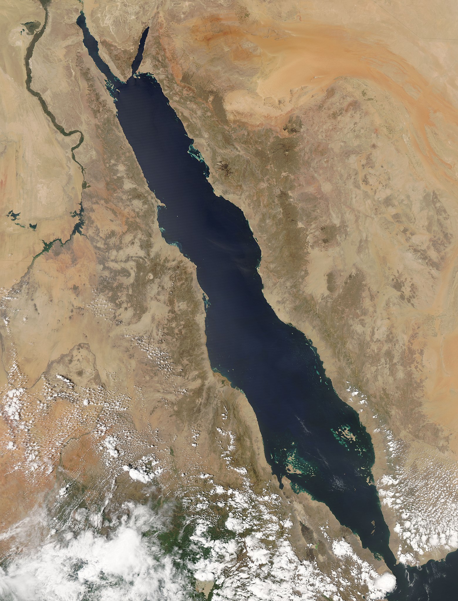
English: "The oblong shape of the Red Sea cuts diagonally through this true-color Aqua MODIS image from September 29, 2004. The sea's deep, clear blue waters stand out in stark contrast to the pale tan and orange sands of the surrounding deserts in northeastern Africa, the Sinai Peninsula, and the western Arabian Peninsula. Clockwise from upper left, the nations are Egypt, Israel, Jordan, Saudi Arabia, Yemen, Eritrea (on the coast of the Red Sea), Ethiopia (bottom image edge), and Sudan. At the southern end of the Red Sea, the Dahlak Archipelago is marked by tiny tan islands and green shallow waters. The dark green ribbon of the Nile River flows northwards through Egypt and Sudan in the upper left portion of the image." (from NASA's Visible Earth) |
| Кадпас | |
| Ӧшмӧс | NASA Visible Earth (Direct link: RedSea.A2004273.1050.250m.jpg |
| Автор | Jeff Schmaltz, MODIS Rapid Response Team, NASA/GSFC |
| Лэдзӧм (Тайӧ файлӧн выльысь вӧдитчӧм) |
PD |
Лицензируйтӧм
| Этот файл находится в общественном достоянии (англ. public domain), так как он был создан NASA (Национальным управлением по аэронавтике и исследованию космического пространства). Политика авторского права NASA гласит, что «Материал NASA не защищается авторским правом, если не указано иное». (См. Template:PD-USGov, страницу политики авторского права NASA или политику использования изображений JPL.) | ||
 |
Предупреждения:
|
Файл история
Личкы кадпас/кад, медым аддзыны файллысь сэкся версия.
| Кадпас/Кад | Миниатюра | Ыджда | Вӧлысь | Пасйӧд | |
|---|---|---|---|---|---|
| ӧнія | 00:44, 4 урасьӧм тӧлысь 2008 | | 6400 × 8400 (6,69 Мб) | Iamunknown | {{Information |Description={{en|"The oblong shape of the Red Sea cuts diagonally through this true-color Aqua MODIS image from September 29, 2004. The sea's deep, clear blue waters stand out in stark contrast to the pale tan and orange sands of the surrou |
Ыстӧдъяс
Тайӧ файлын вӧдитчӧма татшӧм лист бокӧн :
Файлнас глобальнӧя вӧдитчӧм
Тайӧ файлӧн вӧдитчӧны мукӧд викиын:
- Вӧдитчӧны af.wikipedia.org-ын
- Вӧдитчӧны ko.wikipedia.org-ын
- Вӧдитчӧны pt.wikipedia.org-ын
- Вӧдитчӧны rm.wikipedia.org-ын
- Вӧдитчӧны su.wikipedia.org-ын